Sunday, 27 November 2011

Ingleborough

Trig and shelter on Ingleborough

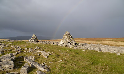
One word sums up today's walk, "Wild." I parked on the high point of the minor road between Ingleton and Clapham, this road forms the southern edge of the Yorkshire dales National Park. There is no right-of-way on to the open fell from this point but access is tolerated. A good path leads up through boggy ground, until the limestone is reached when things dry up a bit. Beyond "Grey Scars" it becomes rather wetter underfoot, "Little Ingleborough" and Ingleborough are clearly in view ahead, the path leads up and eventually onto the broad ridge.  The wind was very strong making sensible walking all but impossible, once I was in the lee of the summit plateau there was a bit of shelter. However as I popped onto the plateau I was subject to the full force of the north-westerly gale, progress was very slow as I inched towards the trig point and summit shelter. Just to top things off a shower greeted me, I didn't hang about long. A couple of photos were snatched, I jogged back down the way I'd come over "Little Ingleborough" and down towards the limestone of "Grey Scars." It was a bit of a battle against the still strong wind, once on the scars I had a mootch round the various sinkholes and potholes in the area. I was treated to a rainbow, then walked the short distance down to the car.
Cairns on Grey Scars

Thursday, 24 November 2011

Nicky Nook

Trig on Nicky Nook
This was a re-visit to the Grizedale valley, near Scorton on the western edge of the Bowland Fells. I had been here for the first time with the RSF on the bike about a fortnight ago. Today I was walking, we followed the Grizedale valley up to the reservoir, were we had lunch. The next leg of the trip was all new to me as we followed the footpath up to the trig point on Nicky Nook. Who could resist a hill no matter how high with a name like that. This small hill sits back from the bulk of the Bowland fells, and as is so often the case the view is all the better for it. Out to the Irish Sea things were sadly a little hazy, but inland things were far clearer. The wind had really got up so we didn't linger long and followed the path north-westwards to reach the minor road which skirts this little hill. The path was very muddy it looked like a herd of Water Buffalo had been driven up it, although I doubt that was the case! The minor road led us unerringly back to the car, a really pleasant stroll.

Sunday, 20 November 2011

RSF ride from Staveley-in-Cartmel

Swans on Sow How Tarn
Today was spent in the murk, the fog/mist persisted all day which was a shame. Although the ride was organised to start from Staveley-in-Cartmel, because I was riding from home I arranged to meet Simeon at the "Hat Trick Cafe", Low Newton. Only one other member was in attendance, after coffee and cake in the cafe we rode down to Staveley and walked up the bridleway into Chapel House plantation. With most of the days height gained, the track led us past Simpson Ground reservoir and down across the allotment. Foxfield then Sow How were passed before we descended again to Sow How Tarn, lunch was taken overlooking the tarn. Widdle Tarn was seen by a short walk from the bridleway. Another descent followed by a sharp climb to Lightwood, and after a couple of hundred metres we were on tarmac for the first time since Staveley. The narrow lanes continued northwards along Cartmel Fell, the dull day meant we were going to run out of daylight so we altered our plans dropping down to Roper ford. The Winster valley was the way back, it made sense for me to break off early returning home via Witherslack, Beck Head, High Sampool, Milnthorpe Marsh and Milnthorpe.

Thursday, 17 November 2011

The "Isthmus" Derwentwater

Catbells from the "Isthmus"
Merely a stroll under heavy skies from Keswick out to the "Isthmus" on the shore of Derwentwater, followed by a good browse round the many gear emporiums that Keswick has to offer.

Sunday, 13 November 2011

RSF ride from Cafe de Lune, Conder Green

Shorts in November, Madness!!
Out with the Rough Stuff Fellowship again, this time south of home. The meeting place today was at Cafe de Lune at Conder Green, and very busy it was too. For those readers who are unsure of the whereabouts of Conder Green, it's a couple of miles south of Lancaster on the Lune estuary. Our ride today was mainly on the road on the western fringes of the Bowland Fells. The area is criss-crossed by a network of quiet lanes through rolling terrain.The route led us to Galgate, before climbing to Abbystead and crossing the River Wyre to reach the unfenced fell road. Onwards and onto our first bridleway, this was only quite short, it did contain the small ford in the photo above. More lanes and we picked up the next and indeed final bridleway which took us down Grisedale. We stopped for lunch beside the reservoir, before descending the rest of the bridleway, then roads to Scorton. A visit to "The Barn" for coffee and cake was in order, duly refreshed more lanes led the group back to Conder Green where we went our seperate ways. I retraced my route of the morning back home via the Lune Cycle Path, Halton and over the hill through Kellet to pick up the Lancaster Canal. A total of almost 68miles for me, in weather which was hard to believe for mid November, many of the group still in shorts!

Thursday, 10 November 2011

Winterburn Reservoir

The dam at Winterburn Reservoir
A short stroll under overcast skies from the hamlet of Winterburn, located 3 miles or so north of Gargrave. Our route was up the wooded valley following Winterburn Beck, (notice a theme here?). The track is metalled, although private all the way to the reservoir. Frustratingly the right of way veers off to the left only 50 metres away from the dam. Lots of signs from British Waterways saying private etc, however a short trespass was in order to catch a glimpse of this little known stretch of water. Photo's taken, we retreated and made our way to the car by higher level field paths, getting caught in a rain shower just before we got back. I was surprised to see the British Waterway signs at the reservoir, presuming it had been built as a water supply for towns and villages in the Airedale. It was however constructed for the Leeds-Liverpool Canal in the late 1800's, canals of course use lots of water through the locks. Hence the British Waterways signs, I don't quite see why it must be off limits to the public though.

Sunday, 6 November 2011

RSF ride from Wilf's Cafe, Staveley

Re-grouping nr Wads Howe in Longsleddle

The weather today was magnificent, I chose to ride from home to Staveley to meet Simeon and the Welsh Border Group who were having a weekend in the Lakes. There was a lot of us and the service in Wilf's was a bit slow so it was 11ish by the time we got underway. We headed off up Kentmere, taking in a couple of short lanes which took us up onto the High House minor road. Beyond High House this becomes unsurfaced and climbs gently up through a number of gates to give access to the open fell. The route took the southernmost bridleway across the open moor, the going a bit boggy to start with but it improves and then descends into Longsleddle. This is one of the quieter valleys, always a joy to visit. The west side of the valley has a little used track/bridleway, we stopped part way along this for lunch sat in the sun until it disappeared behind the hill. Garnett Bridge was our turning point, the minor road took us back up the valley to Sadgill which is the start of the Stile End track. This is rather steep and not that welcome near the end of the day! Of course for every up there's a down and a quick descent was made down to the Hallow Bank road. A puncture had to be repaired at this point, after that an easy ride down Kentmere and a visit to "The Cakery" brought the day to an end. Our Welsh Border group visitors seem to have enjoyed the day, having seen the Lakes at its very best. The day wasn't over for me, I had the 15 or so miles to ride back home. The lanes were very quiet and with a bright moon it made for an enjoyable last leg.    
West end of Stile End track

Thursday, 3 November 2011

Grasmere Circuit

Weir at Grasmere
Leaving the car near White Moss, we dropped down to the River Rothay and walked up the northern bank through Penny Rock Wood to the footbridge adjacent to the weir at the outflow of Grasmere. The trees still had a good few leaves on and the autumn colour were lovely. Almost everyone we met was snapping away, our route followed the shoreline round to Hunting Stile. Along this section we stopped for lunch looking out over the lake, suitably refreshed we continued, the road led us into Grasmere village. A bit of gear browsing then out on the return leg past Dove Cottage and back to the car. The sun had shone to start, but the cloud had increased during the day so we counted ourselves lucky.