Sunday, 21 May 2017

A Wander From Halton Gill

Today's stroll from Halton Gill in Littondale was on new ground for us. I've never been further up the valley than Foxup so.....
Having parked at Halton Gill we followed the River Skirfare upstream across the close cropped turf

Beyond Foxup we climbed through the hamlet and then followed the path as it contoured through Harrop Barns. This eventually drops down to cross Cosh Beck. Our intention had been to visit Cosh and its caves, but we ran out of time!
So we walked back down the farm track passing this new...ish bridge.


And this old bridge!
It's a really quiet valley, and we'll be back when we have more time.

Thursday, 18 May 2017

Over to the West Cumbria Coast on the Motorbike

The weather today was superb, I made the best of the sunshine on the motorbike. Taking the opportunity to ride over to the coast. Here's a few photos of the day.....

I rode over Kirkby Moor and across by Woodland.
The Duddon estuary and Black Combe are the backdrop.

Amazing amount of blossom on this Hawthorn tree in the Duddon Valley

This view from the road over Birker Moor to the Scafell range always commands attention.

The coast at Seascale....

.....and here at Drigg.....

.....and Ravenglass.
It always surprises me the juxtaposition between the Hills and the Coast. It shouldn't, I've visited both for over 50 years.
Anyway a great day, I'm really enjoying the new motorbike.

Wednesday, 17 May 2017

Revisiting The Lorton Fells

Its a long time since I've walked on the Lorton Fells, probably 14-15 years. They're only small in stature but offer great views and usually quiet hills. There were quite a few folk about today mind!

Crummack Water and Buttermere from Low Fell

Looking back at Low Fell as the weather starts to change

Fellbarrow and the light had gone! The paths are much more evident than I remember.

I dropped down to Mosser and followed the disused Mosser Fell road back to the car.
I had never walked over this old road before, so another piece of the Lakeland jigsaw complete.

Wednesday, 10 May 2017

Marilyn Bagging in the Southern Uplands Part 3

Back at the car it was maps out again. I was intrigued by the hills I saw yesterday North of Broad Law, so decided on these 2 Marilyns. Culter Fell and Gathersnow Hill. A quick stop in Biggar to top up my food and then the short drive to Coulter and up beside the Culter Water to park just beyond Culter Allers Farm...

Heading up the Culter Water, the path leaves the road just beyond the second wood on the left

Looking back down the Northeast ridge of Culter Fell.

Next to the trig on Culter Fell, Tinto is the prominent hill in the background.

Theres a good fence to follow all the way to Gathersnow Hill, seen here just left of centre on the skyline.

The summit of Gathersnow Hill, the 2 streches of water are Talla Reservoir on the left and Fruid Reservoir on the right

The view back to Culter Fell

Looking to the West the hills are covered with windmills part of the massive Clyde Windfarm.
We all have our own opinions on these!

I took pretty much a beeline towards Culter Reservoir to pick up the well engineered track. this led down to the reservoir.

It was then about 3km of tarmac down beside the Culter Water back to the car. It was no hardship, the road is only used by a couple of cottages, farmer and the reservoir workers so was very quiet.
Back at the car, I got changed and it was off back home down the M74/M6.
A great trip very fruitful from a hill bagging point of view and good to back out under canvas...well Silnylon! All helped by the superb weather.

Marilyn Bagging in the Southern Uplands Part 2

As I descended from Broad Law I was working out time available for the rest of the day...and the best use of it. I had no desire to drive further than needed. After checking the maps back at the car I decided on the group of 3 Marilyns near Broughton on the A701. So off I went, and parked at the convenient "Walkers Car Park" in the grounds of the rather grand Broughton Place.

It was gone 5pm by the time I'd sorted stuff out. I'd got my backpacking stuff with me and anticipated pitching somewhere on the round of these 3 hills.
Having taken good note of all the burns being almost dry, I packed 2 litres of water...water is heavy stuff in case you hadn't noticed. I always try to carry the bare minimum of the stuff!

The first part of my route followed some of the John Buchan Way....Although I thought I'd be walking more than "39 Steps"

At this point, just below Cowiemuir Hass I left the John Buchan Way and picked up the Northward trending ridge over Broomy Side, Green Law and beyond.

There is an excellent track/quad/path along the broad ridge.

The first of my evenings Marilyns, Broughton Heights. Looking back Southwards over Green Law.

As I walked round the head of Stobo Hope my next top, Penvalla looked along way off.

But after a lot of up and down and a fair bit of contouring I was on the top of Penvalla. It was time to start looking for a spot to pitch my shelter.

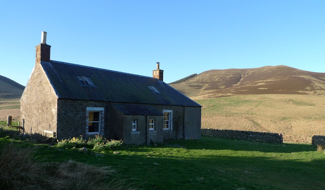
I passed the unoccupied Shepard's Cottage of Stobo Hopehead. Penvalla is in the background.

I found a good place on the col below Hammerhead, got the Deschutes tarp pitched and got organised and food on the go. It had been a wise move to carry water I hadn't seen any since about 200m from the car!

The was no sunrise to speak of, I packed up and headed up into the clag as I climbed up to the top of Hammerhead.

The ridge rolled along, eventually I reached my final Marilyn of the walk Trahenna Hill.  

As I dropped out of the mist I could see that the day was improving. Once again to think of the next hills for the trip....to be continued...

Tuesday, 9 May 2017

Marilyn Bagging In the Southern Uplands Part 1

Back up the M6 and M74 into the Borders today, and then over into Upper Tweed Dale parking at Hearthstane. Broad Law was the first target of the trip...although at this point there was no definite plan......
It's possible to park near the bridge which gives access to the cluster of houses and farm of Hearthstane.

Once through the farmyard you follow the forest road, the shoulder of Broad Law is the high point in the background.

Once out of the forestry the view opens out to the North the track also gives access to the radio transmitter so provides good going all the way to the top.
Here I'm looking North to Culter Fell

The summit, close cropped grass just the place for a spot of lunch!
As I say easy going I was suprised to find it had only taken 75mins.
This is the view roughly South towards Hart Fell 

Back past the wonderful radio transmitter, looking very sci-fi!
I returned to the car the same way, planning the next part of my trip....more to follow.

Sunday, 7 May 2017

River Leven & Roudsea

Hot today! we had a shortish stroll beside the River Leven and round the "Purple" Nature Trail round Roudsea Nature Reserve.

The River Leven, tidal of course at this point.

This picture is taken from the old Lakeside rail line as it crosses the River Leven.
This area never feels like you're on the edge of the Lakes. 

It's ben a fantastic year for Bluebells. There were lots of them today.

The Powderhouse.

Remains of the Tan Bark Peelers Hut deep within the coppiced woodland.
A lovely quiet area.

Thursday, 4 May 2017

Lowther Park

A much easier day today, just a simple stroll in Lowther Park. Very pleasant all the same, the blue skies don't show the strong wind. In the sun and out of the wind it was really warm though...

Lowther Church and the Lowther family mausoleum.

Through the woods which were carpeted with Bluebells.

As we neared the river there were masses of Wild Garlic (Ramsons) instead of Bluebells

The River Lowther was low as most of the watercourses in the Lakes at the moment.

Slightly out of focus Bluebell, the wind made things difficult!

Low Gardens Bridge, which has managed to survive Storm Desmonds destructive flooding.
We followed the River back upstream to the car parked near Lowther Church.