Thursday 31 December 2015

Last Outdoor Trip of 2015...Fatbike from Staveley

A last minute change of plan saw me parked in Staveley with only a very rough idea of where I was going. I knew the dry start was forecast to deteriorate into heavy rain round about lunchtime. So just befor 10 I was off riding up the Kentmere valley, taking Browfoot Lane to gain height easily and giving access to the first of the bridleways.

I rode the bridleways through to High Borrans, the last one very muddy. High Borrans reservoir looking very full, no surprise given the rain we've endured.

Dubbs road next, the lure of the view up the Troutbeck valley spurring me on.

This was as far as I would ride up the Garburn Road today, I never tire of this view of the Troutbeck Fells. Its a great downhill from here to Limefitt, the track has suffered some erosion so a bit of care was required. 

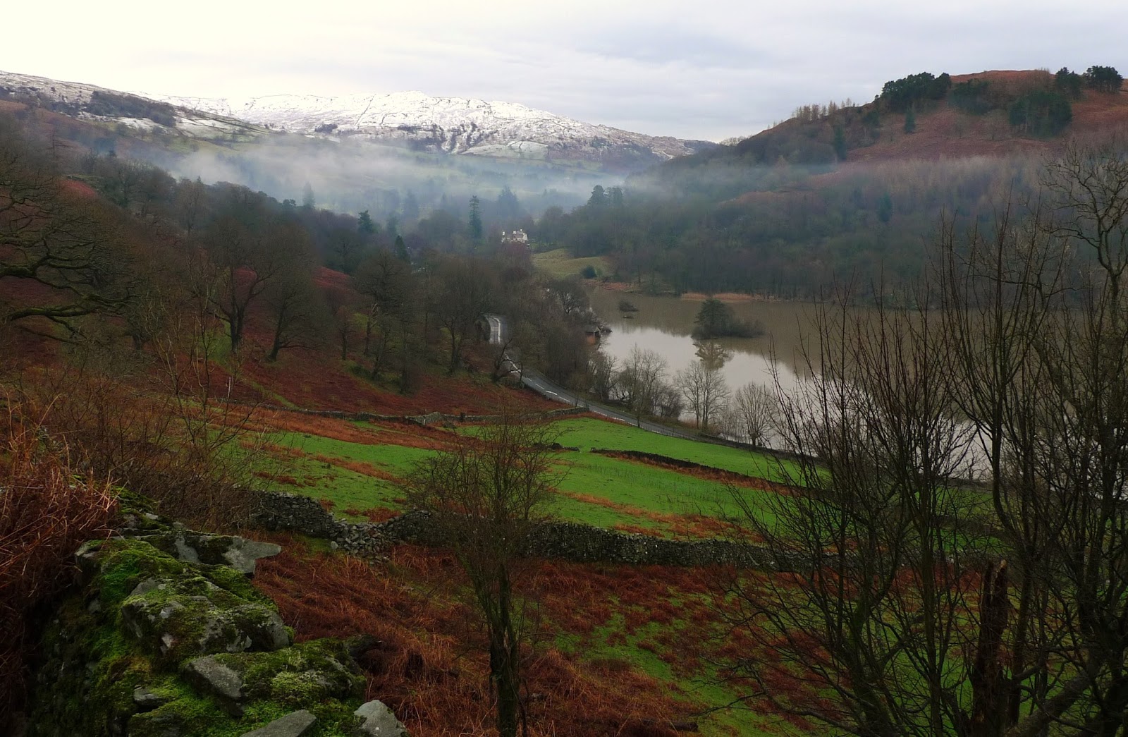
A couple more tracks and the long drag up Robin Lane, Windermere looked grey today. The expected front was evident in the distance. The descent to Merewood was very washed out, these tracks will take a long while to repair.

Middlerigg Tarn...private of course. Wain Lane provided both a mud bath lower down and a full width washout further up. No longer possible to ride up I'm afraid....at least by me!

I'd planned to cross the Troutbeck on this bridleway below Town End, but the bridge has gone in the recent floods. So I detoured via Troutbeck, where the rain started right on cue.
I rode up Longmire Lane, the last of the off road the rain pounding down I rode back to Staveley on the road arriving at the car pretty wet.
So last ride of the year, I'd set myself a target of beating last years mileage total...4111 and have managed to notch up 4347 miles. I'm slightly down on ascent though 180,075ft whereas last achieved 187,635.
It's been a difficult year one way and another, but walking and cycling lets the mind wander and forget some of the trials we all face.
Happy New Year to everyone who passes by here, hope you've enjoyed what I've written and the photographs.
 Thanks have a good one :-))

Sunday 27 December 2015

Gummers How

At last the rain stopped here in the South Lakes, sadly it seems to have moved a little South to Lancashire and West Yorkshire. We took the opportunity to go for a short walk in the winter sunshine...something of rarity here recently!


The view South from near the summit, it looks like there are two rivers flowing out of Windermere....

North from the Summit of Gummers How, the next front forming :-(
It was great to be out in the dry for a change!

Sunday 20 December 2015

Rough Stuff fellowship Ride Over the Knott

The Knott in question is Arnside Knott, not that easy to fit into a logical circuit from our starting point of Carnforth! The day didn't start well for me...I was bitten by a dog before I even got to the start.
 People need to realise, not everyone out for a walk or cycle in the countryside likes your precious pooch! Keep the bloody things under control! I feel now having had time to think about the attack, and the lack of empathy from the owner that I wish I'd reported the incident to the police. In my book a dog which bites...in this case certainly without provocation should be destroyed...and its owner disciplined as well.
Anyway on with the ride.....

Our first track was the "Coach Road" over the shoulder of Warton Crag.
 John had a mechanical....his front shifter coming undone. He was reminded that perhaps he shouldn't have sold his singlespeed! :-) 

A bit blurry, I'm afraid...to fast these guys! As we climbed up below Heald Brow. Then it was along Bottoms lane as we skirted Silverdale.

The relatively new permissive bridleways near Haweswater were ridden, followed by a stretch of tarmac to Arnside. 

It was a bit breezy on the prom at Arnside.

We had a snack to fortify us for the climb over Arnside Knott.

John and Ian on the track over Arnside Knott...So mission accomplished! 

Our route back was via Dollywood Lane....which was rather flooded. I don't think anyone escaped wet feet through here. A cafe stop was in order, the only place open was Beetham Nurseries cafe. Very busy!
As we left the shelter of the cafe, it threw a light shower. I was close to home here, but rode a little way on with the rest of the group before saying my goodbyes.

I took this picture on the way home, there's still a lot of flooding here on the mosses.


Sunday 13 December 2015

Rydal Water Circuit

Just half a day available today, so a stroll round Rydal Water was just the ticket.

Having parked near Rydal Mount we set out along the "Coffin Road"

Here, further along the "Coffin Road" the view over the lake opens up. We were surprised to see that the lake was a sludgy brown colour, a result of the huge quantities of silt washed in during the recent storms.

A dusting of snow on Wansfell, not a breath of wind today so the mist was hanging above the valley.

Back to the car via White Moss and the multi-use track on the South side of the lake.
Another view of the "sludgy" water, very unusual here in the lakes...Brown rivers,yes....Brown Lakes, No!
So only a short walk, but the fresh air is always welcome after a week in the office.


Thursday 10 December 2015

Fat Bike Ride From Chapel Stile

This morning I found myself free at the last minute, I decided to get the fatbike out for a ride through the old slate quarries between Chapel Stile and Tilbirthwaite.

Over Owlets Nest to Little Langdale  and the ford which gives access to the Tilbirthwaite quarries.

Firstly I explored the West side of the valley I crossed over to Hodge Close...the sun came out at last! So I had my lunch sheltering from the bitter wind.

Crossing the Coniston road at Oxen Fell the steady climb along the Arnside Intake track, I then took the bridleway over Iron Keld.
As you start the descent the Langdale fells fill the view.

Further down the track I stopped to take this photo of the Eastern Fells....Still no snow, even though it felt cold enough for it.

The descent just keeps on coming. A very full Elterwater in the centre of the picture.

Back to the car along the multi-use path beside the swollen River Brathay and Elterwater.
The weather wasn't as good as forecast, and the tracks were very wet.
I can definitely say I need some new waterproof trousers for offroad cycling! :-)


Sunday 22 November 2015

Brandlehow....Beside Derwentwater

Sometimes life isn't quite how you'd like it.
I've recently had a spell of that....but days like today make things a lot better.

Thursday 29 October 2015

Conishead, Salt Cotes and Canal Foot.

A short stroll in the warm afternoon sun, having parked in the overflow carpark at Conishead Priory.

Firstly through the mature woodland on the permissive path to the shore.

Then along the shore...not much of it available at first due to very high tides!

Footpaths and little used lanes took us to Sand Hall and this old chimney in the middle of a field. An old brickworks chimney apparently.

Through Salt Cotes and round Hammerside Point to Canal Foot.
Then it was back much the same way.
Very mild today, hard to believe its almost November!

Sunday 4 October 2015

Great How

Great How I hear you say....where's that? Its the little bump with the great views adjacent to the Thirlmere dam. Its a "Birkett" as well!

Parking beside the A591 Castle Rock is well seen across the valley, I understand it may soon change its appearance....a huge rockfall is imminent 

A permissive path gives access to the top.
This is the view Northeast from the North top, even in the dull overcast weather today the scene was excellent.

This is from the South top (and the higher) Brown Cove on the left and the Central Fells to the West of Thirlmere

Raven Crag across Thirlmere, not much wind today we could hear climbers on the crag calling.

Almost the full length of Thirlmere is seen from here, the autumn colours are just starting here in the Lakes. We returned to the car by the lakeside path and lane past ridge end Farm.
So there we have it, Great How. A grand way to spend a few hours of anyones day, pick a clear day and see all it has to offer!

Thursday 1 October 2015

BMW Day Ride Over The North Yorks Moors to Whitby

A good forecast, and possibly the last really good day off I'd have on the motorbike. It's been a while since I've visited the North Yorks Moors and Whitby, so off I went!

The best way for me to get over to Wensleydale is via Ingleton and Ribblehead.
The viaduct looking magnificent, not a cloud in the sky!

Wensleydale. my favourite of the Yorkshire Dales.

All the way down Wensleydale to Masham, a coffee in the square as I watched the world go by sat in the amazingly warm sun.

Then it was across the Vale of York and over Sutton Bank. I turned off to pass Rievaulx Abbey...guarded by geese by the look of things.

Leaving the A170 at Kirbymoorside I headed onto the North York Moors, lots of heather was being burnt. here between Gillamoor and Rosedale.

I stopped on Rosedale Bank near the old kilns at the Ironstone works for a late lunch.

I just sat and admired the wonderful view up Rosedale.

I rode into Rosedale and then back out and over to Egton Bridge. 

Just a few miles further and I was in Whitby, pleasingly free of crowds!
Heres the abbey seen through the old whale jawbones caught in less enlightened times.

Looking back to Whitby proper the South side of the harbour a mass of pantile roofs.

Leaving Whitby, I followed the coast, through Sandsend and making a visit to Runswick Bay. This view is from Port Mulgrave...a much quieter spot. I lingered for a while before heading back West.

Riding over into Commondale then Kildale, the light was fading. The air was heavy with smoke as well from the heather burning.
I rode home via Scotch Corner and the A66.
A great day....glad I kept the BMW...nearly sold it earlier in the year because I wasn't using it enough!

Sunday 27 September 2015

Indian Summer Stroll from SunBiggin

Proper hot today! I could hardly believe it, we walked nice and slow to soak up the amazing views to both the Howgills and Pennines. Only saw one person and he was on a horse. Other than the C2C path this is a very rarely walked/cycled area by the lack of prints.

As we climbed away from Sunbiggin Farm the Shap Fells dominate the West.

Once the broad ridge is reached the Pennines are arrayed before you, Cross Fell the high point of course.

Barely a breath of wind as we sat beside this ancient cairn had our lunch and soaked up the views.

A descent on a little used bridleway followed by easy ground across access land brought us to Sunbiggin Tarn. The Howgills and Wild Boar Fell beyond.
More bridleways and quiet lanes took us back to the car West of Sunbiggin Farm.