Thursday 31 January 2019

Dubbs Road to Garburn Quarry

An easy afternoon walk today, we parked beside the Moor Howe Road near Windermere and wandered along the snow covered Dubbs Road in the Winter sunshine. Great views though.....

Dubbs Reservoir frozen over today, as far as I could tell it never got over -1c today. The sun made it feel warmer tough, no wind either unlike yesterday.

The lower slopes of Wansfell with the Coniston fells beyond.

We only went as far as the quarry today, far enough to take in the wonderful view to the head of the Troutbeck valley...I never tire of this view...Great isn't it!
We returned the way we came, soaking up the sun!

Wednesday 30 January 2019

Some Borrowdale Synge's

The was some doubt as I left home this morning with barely a scattering of snow on the car as to whether I would be able to get over Dunmail Raise due to snow according to the radio. True enough the road was well covered when I got there, just passable...in fact the snowplough was just coming over the top of the pass. Once parked in near Grange in Borrowdale, (where the was much less snow) I headed through the village to start the steep climb to Nitting Haws.
As usual here's a few photos from the day....

This is a favourite path of mine, although steep it seems to gain height quickly and provides amazing views

Like this one back towards Derwentwater, a snow shower passing over Walla Crag & Bleaberry Fell

The path crosses below the dark crag. I stopped here got the axe out and put my Microspikes on

The summit of Nitting Haws, first of today's Synge's. Helvellyn is in the distance.

Another view of the summit rocks of Nitting Haws, Stonethwaite snaking away into the distance.

The snow covered rocks on the top of Low Scawdel looking North.
Skiddaw and Blencathra hanging onto low cloud.

A direct line to my next Synge was out of the question, so I headed upwards to the High Spy ridge.
This proved to be very hard work!! Here looking back to the sunlight on Low Scawdel, it took me 45mins to reach this point as I broke trail through the now very deep drifted snow overlaying deep heather...Oh joy :-(

Cloud was skimming the top of Dale Head, but in the distance the sun was catching Base Brown.

Having floundered down to the col, I picked up the fence which leads unerringly to this point...the summit of High Scawdel. This was my last summit of the day.

I turned to retrace my route beside the fence.

A winter wonderland!

I left the fence and walked down beside Rigghead Quarries, the snow thinned out as I descended.

I crossed Tongue Gill on the bridleway which would lead me back to Grange.

Stopping briefly to take this picture below Castle Crag.
Another great day, I enjoyed today in spite of the flogging through deep snow and vegetation!!

Sunday 27 January 2019

Unclimbed Synge's East of Coniston Water

A wild, windy day today...there would be no pleasure in being up high. Although my current task is leading me to lower tops. My targets today were 2 Synges between Coniston Water and Grizedale Forest. This is an area which is very familiar to me, however I have generally been on 2 wheels of one type or another. I had been very close to both of today's tops, but never visited the actual summits.

As I parked at Dodgson Wood car park on the East side of Coniston Water the wind was whipping across the lake. The view of the Coniston Fells would be ever present during the walk...no bad thing at all!

The permissive path gains height easily...I don't think I've ever been on it before...and once clear of the deciduous woodland the views opened up.

Low Parkamoor, a sign calls it "The Cottage In The Clouds". You'll need to walk or cycle to visit/stay here, no access even for a 4x4..to the door anyway.

Following the bridleway North brings you to within 200m of The Park, seen here at the far right of the image. I have been here countless times over the years...so close yet so far!

This is the view from the summit looking West, this photo doesn't show the intensity of the wind. i had to kneel down to try and steady the camera.


Having retraced my route to just South of Low Parkamoor I headed across the moor then South to reach here Heel Toe Hill! Why is it called that I wonder? This was my second Synge of the day it's actually not far from the Wainwright Outlyer, Top O' Selside.
Black Combe is prominent in the distance.

It was incredibly wild on the top, so it was good to descend back the way I'd walked earlier.
the park is in the middle distance to the left of the conifers in this image.

Once on the bridleway it was back to the car by my outward route.
These Catkins caught my eye..Spring must be on the way, although it didn't feel it today.
A relatively short and easy walk but satisfying to tick a couple more hills off.

Thursday 24 January 2019

Mopping Up

A tidying up sort of day today. Bagging Synge's in the Northeastern corner of the Lakes. I've not got  many left  to tick now, so my thoughts are turning to whats next as I thrash across the pathless terrain on many of these walks. There was a scattering of snow as I left home, rather more when I parked at High Row above Dockray.
Below is a selection of photos from the day.....

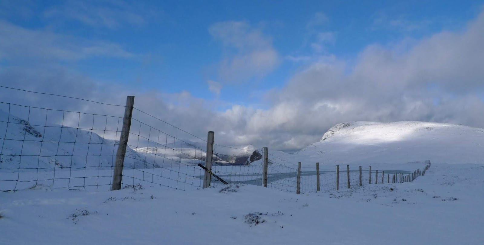
First top was Matterdale Common (the high point in this image), There were several people setting off ski touring as I walked along the Old Coach Road.

The path beside Groove Beck made for easy progress, with a sort ascent to the top of Matterdale Common. The cloud was starting to disperse revealing Blencathra and closer to hand Wolf Crags.
 I returned to the car the same way, I was surprised how much snow/ice had gone from the lane back to the A5091

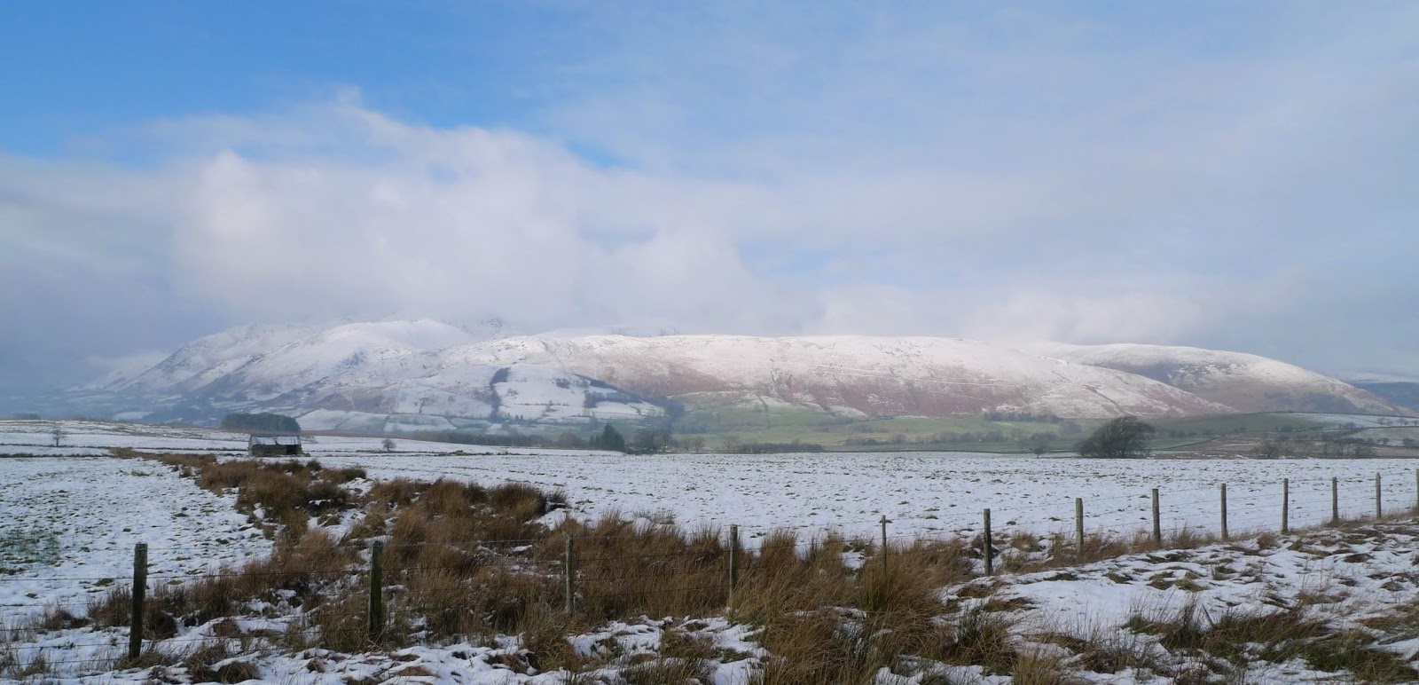
Next on the agenda was Loftshaw Hill, the ascent of which requires a trespass. All I'll say is I parked on the old A66. Blencathra, Scales Fell and Souther Fell formed a great panorama to the West.

Hard to tell exactly where the actual summit was on Loftshaw Hill, probably one of the molehills in the foreground from what I could tell!

This is the summit of Greenah Crag my next Synge of the day, again a trespass is required to visit the top. So I'll leave my description at that, it was rather an uninspiring walk to get here anyway.

This wall corner is top of Hutton Roof, surely the easiest Synge to bag? Only 200m from the road on a public footpath kind of behind someones house!
A great view of Carrock Fell though, and there on the shoulder of High Pike was West Fell my last Synge of the day. 

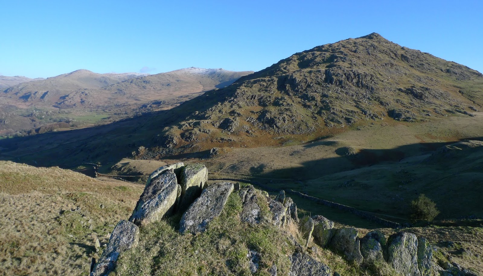
A short drive from Hutton Roof and I parked at Calebreck. There are many paths heading in the general direction of High Pike and West Fell, I chose to head across to pick up the path above Carrock Beck. Leaving it when South of the summit of West Fell, I made a beeline North picking up the path in the image. the cloud was just skimming the summit of High Pike.

This is the top of West Fell, or at least somewhere round here!
Carrock Fell is in the background.
The wind was bitter, and with no shelter I quickly turned and made as straighta route as possible back to the car. The terrain is generally easy going on these slopes...just the old mine stopes to be wary of!!...Only joking they are further West!
So another area cleared, and other than Greenah Crag a very enjoyable day.

Sunday 20 January 2019

A Few More Synge's...Central Fells This Time

After some indecision on my part I had a bit of a late start this morning. I parked opposite Causeway Foot Farm in the Naddle valley, taking my life in my hands as I walked south along the A591. My plan was to walk a loop round 3 Synge's (4 actually but I'd done 1 many times!). I survived the traffic and took the footpath which contoured above Brackenrigg and Shoulthwaite Farm, the walk beside Shoulthwaite Beck is lovely. This valley deserves to be better known really.
As usual there follows photos of the day.....

Looking back down Shoulthwaite Gill towards the Naddle valley

Once I reached Mere Gill I climbed out of Shoulthwaite Gill, rather steep...gave me a chance to look back East to Castle Crag hillfort and Benn cloaked in conifers.

Once the angle eased the hard going commenced.
I contemplated...Would I remain dryshod?...Would I retain my Sanity?
Nahh...That's long been Lost!!

Here on the fist of today's Synge's "Bleaberry Fell South East Top", the sun made a brief appearance. Bleaberry Fell is in the background.

From the same point looking Northeast..ish, Blencathra and Clough Head in the background
 High Rigg down below.


To get to my next unclimbed hill I really had to visit Bleaberry Fell, no great hardship. The Synge I'd climbed earlier is the high point to the left of the cairn.

The next hill on the agenda Dodd Crag seen here in the centre of the image.

The view from the "top" of Dodd Crag, sadly the sun had disappeared. From here it looked a fair way to Pike, my last hill for the day.

A couple of walls to surmount to get here on the top of Pike. This didn't look of feel like the high point, but the info said a bolt in a rock...and there it is..in the centre of this photo.
The weather was closing in as I descended towards Castlerigg, the rain started as I walked across the fields to the A591. Back along the road to the car, 3 more ticks on the list! 

Thursday 17 January 2019

Two Walks Above the Duddon Valley

A really beautiful days weather today, barely a cloud in the sky but a very cold Northerly wind meant no unnecessary hanging about. I had 4 Synge's to climb in this area and had in mind to do them all today in 2 separate walks.
As is my habit here's a few photos of the day....

Having parked on the top of Kiln Bank Cross, I set off along the Park Head Road. My first top was to be Brock Barrow...seen here directly above the track in the foreground.

I made quick progress along the track to it's highpoint. It was then only a short climb to the top passing this small dud of water. Stickle Pike is the prominent peak.

There was a cracking view of Caw from the summit.

Back down to the track and up on to "Park Head Road Top"...strange name (it's not near the top of Park Head Road!). Here we are looking back at the earlier ascended Brock Barrow. it was then just a short way back to the car.

Having driven down to Hall Bridge and parked, I headed along the minor road to Wallowbarrow.  

This is the final approach to Wallowbarrow Heald, can you spot the path...no neither could I because there wasn't one...no animal tracks nothing. It was the best part of a km from the Grassguards track, all like this....I may well have nightmares about this tonight!

This is the top of Wallowbarrow Heald and a splendid view across Dunnerdale to the Coniston Fells

It' only a short distance to the next Synge Iron Crag, with another excellent view. It was just possible to see Seathwaite Tarn from here. It was time to head back all my summits for the day had been attained. I chose a different route back, it involved a small trespass but was worth it.

I passed the old farmstead of High Stoneythwaite, a very isolated place indeed. No vehicle access to this one...quad only!
Another great day, superb weather, 4 more Synge's bagged....I did question my sanity on the ascent of Wallowbarrow Heald though!