Wednesday 25 December 2019

Lingmoor Fell....A Christmas Day Walk

Superb weather today....to good not to climb a hill even a small one! I chose Lingmoor Fell and was on "the Trail" just after 10am. Having parked in Chapel Stile, I walked up through the quarries and into Base Brown wood. Once on the open fell the views open up....and I met the first people of the day!...coming down!! Here's a few images from the day....

East to Loughrigg and beyond

West along the broad summit ridge

Layers looking down Tilbirthwaite

Pano from the summit of Lingmoor Fell

Crinkle Crags and Bowfell

Side Pike 

Looking back at "Fat Mans Agony" ...good job this was undertaken before Christmas Dinner!

From Side Pike I descended to pick up the Cumbria Way...great views of the "Pikes"

The bridge here near Oak Howe was in the sun so I stopped for a snack...just a flat stroll back to the car.
An excellent walk, the Strava track is here should anyone wish to see my route in more detail.

Saturday 2 November 2019

Crinkle Crags

I'm a bit late posting this, I actually did the walk on Wed 30th October....in fact I nearly didn't bother. But it was a pleasant enough day, shame I was in clag on the very top. There was quite a bit of ice, which surprised me as there hadn't been a frost since Monday. I parked on the roadside near Rossett Bridge and headed off along the tarmac to Stool End Farm, then into Oxendale.
When I returned home I thought the photographs a bit meh...but on reflection perhaps not to bad....here's a few from the day...

It's a stiff climb out of Oxendale, but looking back the views were opening up. it was rather more overcast than the forecast.

The puddles were frozen as I passed below Red Tarn. Here I'm a little way up the path towards Great Knott, looking across towards Wetherlam in the background.

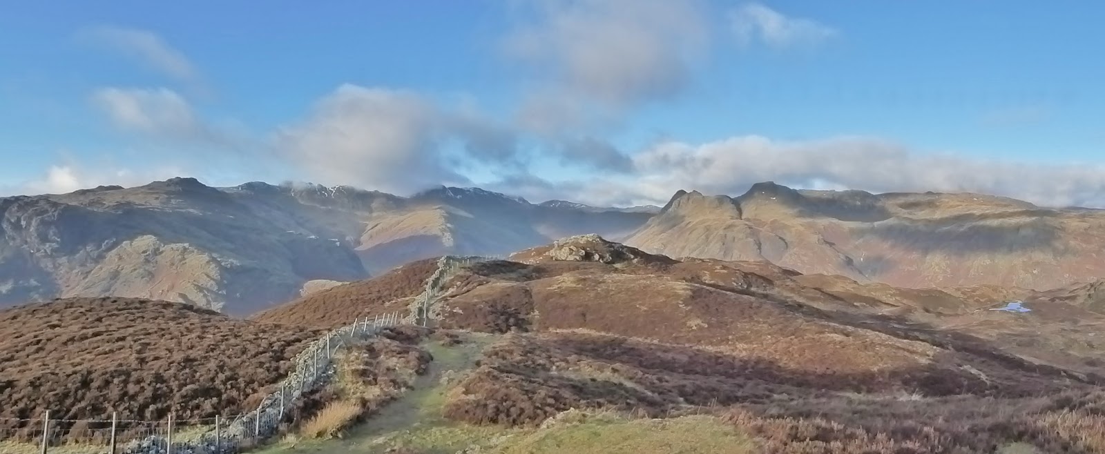
Further up, just below the 1st Crinkle, and with Gladstone Knott and Great Knott now below me. The Great Langdale valley stretching away.

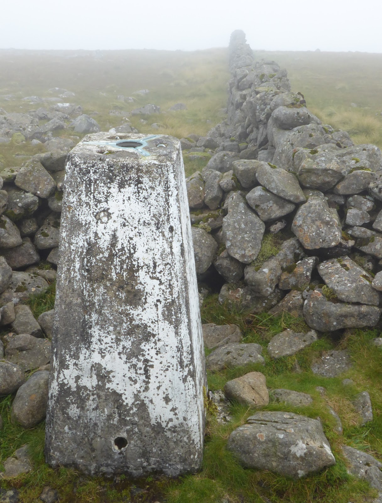
The cairn on Gunson Knott (I think), low cloud on the Scafells

The l'arl tarn below Gunson Knott, the cloud has lifted compared to the last image!

I continued on to Three Tarns, the wind was bloody freezing! so I didn't hang about. The weather didn't look as if it was going to improve (although it did :-( ) so I descended by The Band.
A great view of Lingmoor Fell...I was thinking I would probably have been better going up there!

Just inside the Intake Wall the sun really made an appearance...so I snapped this view of Langdale.
Only really half a day,  and not what I'd planned when I left home.
The Strava track can be found here should anyone wish to see my route.

Wednesday 2 October 2019

Catbells, Maiden Moor and High Spy

A rather different day to the last time I was on these hills back in January . A superb days weather today though, the only problems road closures and then actually getting parked. I eventually found a place above Manesty Park. So back up the road I walked to gain a foothold on the first fell of the day....Catbells. This is a hill I've avoided for many years because of the crowds. I had thought it would be relatively quiet midweek in October...how wrong I was! Below are some images of the day, many are panoramas so a click will reveal their full glory...or not YOMV!

From the road I took the forbidden route up Skelgill Bank. The view across Derwentwater to Skiddaw and Blencathra really excellent.

From the summit of Catbells looking North..ish the view is similar but different.

And to the Southwest the upper Newland Valley and it's surrounding hills.

South for me though, along the ridge. Leaving the majority of the crowds behind as well.

Looking back from Bull Crag to Catbells.

After crossing Maiden Moor I arrived at High Spy. It's a great viewpoint for Dale Head, which dominates the image. I had lunch here in the warm sun. 

I managed to get down to the top of tongue Gill dryshod amazingly. The Helvellyn Hills fill the horizon.

After passing through Rigg Head quarries and skirting above Lingy Bank I stopped to take a couple of photos of Castle Crag and the view down Broadslack Gill towards Keswick and Skiddaw.

It was then back to the car using mainly the Cumbria Way as far as brandlehow Bay before climbing back up to the car.
A great day, I'd planned to walk the Newlands Horseshoe, but the road closures made that difficult...this was an excellent 2nd choice.
The Strava track can be found here should anyone want to see the exact route.

Wednesday 18 September 2019

Corserine & Shalloch on Minnoch

Today's walks were all about finishing the Southern Upland Corbett's. I drove up after an early start arriving at Forrest Lodge just after 9.30am. At this stage I was unsure whether I would just climb Corserine or drive round and climb Shalloch on Minnoch in the afternoon. Images of the day follow as usual....

They're keen on notices/signs on the Forrest estate!

Off up the logging road, (I was passed by 2 artic's) Corserine is more or less in the centre of the distant ridge.

Out of the forestry and onto the open hill...all looking nicely wild.

Sadly the actual summit was shrouded in low cloud when I was there. I turned round and headed back on the route of ascent.

Just a few metres lower at Hennessey's Shelter and I was below the cloud with a great view over to the East. Cairnsmore of Carsphairn is to the right of the cairn.

Castlemaddy, Goats Crag and Meaul form a long ridge to the North.
I returned to the car nd decided that I had enough energy for the expected effort to climb Salloch on Minnoch. So after a snack drove the 30 odd miles round to the high point of the minor road which runs between Straiton and Newton Stewart.

I decided on a beeline to intersect the ridge...BAD choice! Looking back to the car which is to the right nd beyond the group of trees. This was very hard going.

Once on the broad ridge there was a path, quite wet for much of the way...but a million times easier going than the heather bashing I'd endured earlier.
The prominent highpoint in the photo is the site of the trig but not the actual summit.

The actual summit, and a great view to the South and Southeast. The day had improved dramatically, it was now quite warm even with the breeze.

Looking to the highpoint of Shalloch on Minnoch from the trig.
Back along the broad ridge, all the way this time...

The path went all the way back to the road, very wet in places...but way better than my outward route...even with the km back uphill on the road.
So that's the Southern Upland Corbetts completed. Even though they are the highest hills in the area they would appear by the path usage to be rarely visited...indeed I have met very few other people on them...admittedly generally midweek.
A great days walking/Bagging!

Tuesday 27 August 2019

Cairnsmore of Carsphairn

Corbett bagging today, in the Southern Uplands. Cairnsmore of Carsphairn....although you might have guessed that from the title! I drove from home this morning, a bit of a last minute decision. I arrived at the bottom of the track about 10.30 and left the car just before 11.00 am. I used the trade route, here's a few images from the day.

The track follows the Water of Deugh for a while.

Before it climbs away, and crosses the flanks of Willieanna and Dunool. The flanks of Cairnsmore in the distance where shrouded in mist.

Shortly after the track ends the Polsue Burn is crossed at this footbridge. from here the wall leads unerringly to the summit...This is one walk where it would be very difficult to get lost IMHO of course.

The summit...no view to distant unclimbed hills today :-(
I waited for a short while but the was no sign of the mist/cloud clearing.
I descended by exactly the same route of ascent.

Following the wall, not to much of a path as you can see.

A little lower the view to the West, albeit rather hazy.

It wouldn't be Scotland in August without a bit of heather!

I took another picture here because I felt the light was a little better...I'm not so sure now.
A good walk, new ground, and a Corbett and of course a Marilyn tick.

Wednesday 21 August 2019

Crummackdale & Thieves Moss

Todays walk started in Austwick in the Dales...the Lakes are out of bound for me until the school holiday madness subsides! From Austwick Bridge I walked up Wood Lane and on towards Wharfe. As usual here are few photos from the day....

Moughton Scar & Austwick Beck from Austwick Bridge

Slightly off route, but always worth a visit this is Washfold above Wharfe

Further up Crummackdale and the skyline between the Gateposts is where I was heading.

The cairn of Capple Bank on Moughton Scar.

Having sheltered from the edge of a passing shower having lunch I crossed over to Thieves Moss.
The above photo is of a recent "dig" by some potholers...there was the sound of a significant fall of water not far in!

It was very windy on the edge of the scar, in-fact the day had deteriorated whilst I'd been out.
Here we look down onto Thieves Moss, with Pen-y-Ghent prominent in the background.
I returned to Austwick by the bridleways and footpaths on the Western edge of Crummackdale.
Today had a bit of an Autumnal feel to it at times...colours should be improving....not quite as much "Green"!