Showing posts with label Corbetts. Show all posts

Wednesday, 18 September 2019

Corserine & Shalloch on Minnoch

Today's walks were all about finishing the Southern Upland Corbett's. I drove up after an early start arriving at Forrest Lodge just after 9.30am. At this stage I was unsure whether I would just climb Corserine or drive round and climb Shalloch on Minnoch in the afternoon. Images of the day follow as usual....

They're keen on notices/signs on the Forrest estate!

Off up the logging road, (I was passed by 2 artic's) Corserine is more or less in the centre of the distant ridge.

Out of the forestry and onto the open hill...all looking nicely wild.

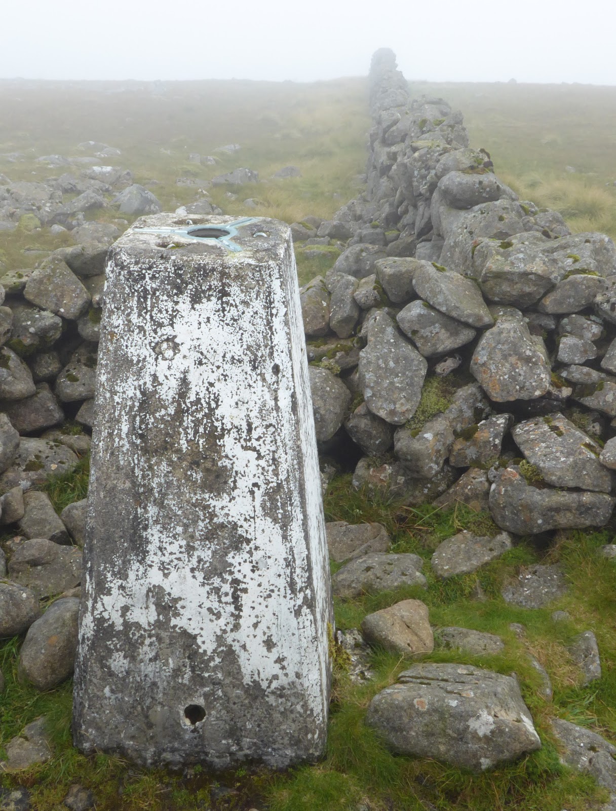
Sadly the actual summit was shrouded in low cloud when I was there. I turned round and headed back on the route of ascent.

Just a few metres lower at Hennessey's Shelter and I was below the cloud with a great view over to the East. Cairnsmore of Carsphairn is to the right of the cairn.

Castlemaddy, Goats Crag and Meaul form a long ridge to the North.
I returned to the car nd decided that I had enough energy for the expected effort to climb Salloch on Minnoch. So after a snack drove the 30 odd miles round to the high point of the minor road which runs between Straiton and Newton Stewart.

I decided on a beeline to intersect the ridge...BAD choice! Looking back to the car which is to the right nd beyond the group of trees. This was very hard going.

Once on the broad ridge there was a path, quite wet for much of the way...but a million times easier going than the heather bashing I'd endured earlier.
The prominent highpoint in the photo is the site of the trig but not the actual summit.

The actual summit, and a great view to the South and Southeast. The day had improved dramatically, it was now quite warm even with the breeze.

Looking to the highpoint of Shalloch on Minnoch from the trig.
Back along the broad ridge, all the way this time...

The path went all the way back to the road, very wet in places...but way better than my outward route...even with the km back uphill on the road.
So that's the Southern Upland Corbetts completed. Even though they are the highest hills in the area they would appear by the path usage to be rarely visited...indeed I have met very few other people on them...admittedly generally midweek.
A great days walking/Bagging!

Tuesday, 27 August 2019

Cairnsmore of Carsphairn

Corbett bagging today, in the Southern Uplands. Cairnsmore of Carsphairn....although you might have guessed that from the title! I drove from home this morning, a bit of a last minute decision. I arrived at the bottom of the track about 10.30 and left the car just before 11.00 am. I used the trade route, here's a few images from the day.

The track follows the Water of Deugh for a while.

Before it climbs away, and crosses the flanks of Willieanna and Dunool. The flanks of Cairnsmore in the distance where shrouded in mist.

Shortly after the track ends the Polsue Burn is crossed at this footbridge. from here the wall leads unerringly to the summit...This is one walk where it would be very difficult to get lost IMHO of course.

The summit...no view to distant unclimbed hills today :-(
I waited for a short while but the was no sign of the mist/cloud clearing.
I descended by exactly the same route of ascent.

Following the wall, not to much of a path as you can see.

A little lower the view to the West, albeit rather hazy.

It wouldn't be Scotland in August without a bit of heather!

I took another picture here because I felt the light was a little better...I'm not so sure now.
A good walk, new ground, and a Corbett and of course a Marilyn tick.

Wednesday, 22 May 2019

Hart Fell...In the Moffat Hills

So, having burnt some more fossil fuel, I found myself high in Annandale near Ericstane. Today's initial target was the Corbett of Hart Fell. From there I would see how I felt and how the weather fared. Parking near the community hall off I went....

The hamlet of Ericstane and the head of Annandale

The Auchencat Burn which I would follow for the first part of my route.

The scree filled gully contains "Hartfell Spa"...next on the agenda.

This is the "Hartfell Spa" a chalybeate well, apparently good for curing ills...although the water looked like it would give you ills rather than cure any!

Things got a bit scrambley near the top of the gully

And here looking back down the gully towards Annandale. The prominent hill is I think Queensberry.

Lots of Mayflower about today.

Click on the image to increase the size otherwise you won't see all the wind turbines!
I have mixed feelings about them...there's an awful lot of them here though.

This is the subsidiary top of Arthur's Seat, to the left of the cairn in the distance is Skiddaw and over to the right of the image Criffel.

Yours trulyon the summit of Hart Fell gazing towards White Coomb.

It was a brutal descent beside the fence, out of view before climbing back onto the broad ridge in the middle of the photo...Whitehope Heights..a Donald.

Continuing beside the fence along the broad twisting ridge I joined the Annandale Way...marked by this cairn.

I stpped at the next col for a snack and drink, a great view down Annandale

Over my last top of the day Great Hill, I then picked up this great path which contoured under Strait Step. 

There were excellent views of the Devils Beef Tub from the path.
The path took me down to the valley floor at Corehead, from there it was road/Land rover track back to the car via Ericstane.
Superb weather, and a great horseshoe walk. Only one person seen (on Hart Fell summit) all day, quiet hills for sure.

Tuesday, 9 May 2017

Marilyn Bagging In the Southern Uplands Part 1

Back up the M6 and M74 into the Borders today, and then over into Upper Tweed Dale parking at Hearthstane. Broad Law was the first target of the trip...although at this point there was no definite plan......
It's possible to park near the bridge which gives access to the cluster of houses and farm of Hearthstane.

Once through the farmyard you follow the forest road, the shoulder of Broad Law is the high point in the background.

Once out of the forestry the view opens out to the North the track also gives access to the radio transmitter so provides good going all the way to the top.
Here I'm looking North to Culter Fell

The summit, close cropped grass just the place for a spot of lunch!
As I say easy going I was suprised to find it had only taken 75mins.
This is the view roughly South towards Hart Fell 

Back past the wonderful radio transmitter, looking very sci-fi!
I returned to the car the same way, planning the next part of my trip....more to follow.