Thursday, 28 January 2016

Jackdaw Scar, Kings Meaburn

We had to be in Appleby today, but with a couple of hours to spare we repeated a walk we did 5or 6 years ago (we think!). The weather was against us, very wet.....what a change :-)
Anyway here's a few pics before the camera had to be hidden from the deluge.

Having parked in Kings Meaburn a little bit of road followed by some very muddy field paths led us down to Chapel Bridge.

The River Lyvennet runs below the village through a relatively narrow valley.
There was evidence throughout of the recent high water levels, here it had scoured the path clean.

I had a quick mooch up to the climbing crag part of the scar...it looked grim!

Quite alot of fungi about today as well, presumably because of the mild weather?
Not a long walk but good to get out in the fresh air as always.

Sunday, 24 January 2016

RSF Ride in Grizedale

Our off road ride started today from Force Forge. There was only 4 of us as we left to do a circuit of the Grizedale valley, heading first over to Satterthwaite.

The initial climb was up a forestry road, before this morass greeted us!
It was only for 50m or so and hardly surprising considering the deluge we've suffered over the past few months.

Having left Satterthwaite behind us we climbed Moor Lane. This rises in 3 stages (most of it rideable) to reach Parkamoor.

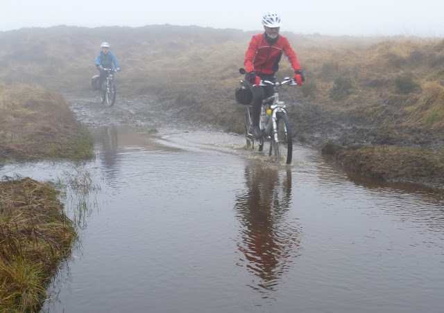
Parkamoor was as wet as ever! Here Nick and Eileen ford one of the shallower "puddles" 

At Parkamoor Farm we headed North, and with the wind behind us forged on in the mist and murk! (sorry about the blurry pic!)

We descended the bridleway through Park Plantation.

To arrive at the Grizedale Visitor Centre, and the welcome cafe.

We left the visitor centre on the road heading up to Moor Top, before bridleways Southwards brought us back down the Eastern side of the forest. The descent of Breasty Haw bringing us back to Satterthwaite

We could have gone back to the cars by road, but instead opted to reverse our first bridleway instead.
Not that far today, but a good ride in good company.
For those interested in our route the Strava track is here

Sunday, 17 January 2016

Fatty Feels Snow On It's Tyre's For the First Time

Fatbikes aren't for folk who don't want to chat when they meet people on the trail. I'll soon have had my Felt Double Double 30 for 12 months, a recurring theme is peoples reaction to the fat tyres. Usually "they must be hard to pedal", no they aren't...."that looks heavy", actually its lighter than most full suspension bikes. And of course..." isn't it just for riding on snow?".....well no they make great trail bikes.
But yesterday it snowed, so off to Kentmere I went to ride my nearest "proper" trails to see if a Fatbike is good on snow?

Brow Head Lane gives a good opportunity to gain height on tarmac, today once past Brow Head the climb was on pretty much pristine snow.

Then along Grassgarth Lane which gave me access to Kentmere Park, the weather was looking poorer as a front started to make inroads from the SW.

The village of  Kentmere is well seen with Shipman Knotts and Kentmere Pike as you descend to Kentmere Hall. It pays to keep your mind on the job in hand down here, recent storms have washed some of the track out....leading to me taking a tumble!

Picked myself up and dusted the snow off....silly old fool!

The start of the big climb of the day Garburn Pass, definitely easy with a bit of snow and ice to bind the loose rocks and stones together

Of course it's not all rideable uphill on this side of the pass, not by me anyway.

But once on the top its ALL rideable, just over 6" of snow on level ground I'd say?
The flat light led to one or two interesting moments as the drifts were almost impossible to spot. 

From the Dubbs Road a bit of tarmac to High Borrans and then back onto the outward bridleways and back along Brow Head Lane to the car. Quite alot of the snow had gone down in the valley.
So is a Fatbike any good in snow....Oh YES, its superb!!

Friday, 15 January 2016

High Dam, Finsthwaite

Its been quite a few years since we've visited this picturesque sheet of water. It always reminds me of Scotland, probably because of the Scots Pines I think. Its not very far, the reward is great for so little effort.

This has appeared since we were last here, a relief map of Finsthwaite and High Dam.
Rather well made too!

The Dam at High Dam, we crossed and did a clockwise circuit.

North from the Southern shore, this doesn't show the bitter wind.

East across the tarn to Gummers How, the snow had just caught here as you can see.

Again this boardwalk was new to us! Thank goodness its been provided, it was always very wet across here.

Back lower down out of the wind the sun had some warmth in it, this field was mushy and very slippy.
So there we have it High Dam, worth an hour or two of anyone's time IMHO!

Friday, 1 January 2016

Silverdale Coastal Amble

A short walk beside the sea (well sand/mud today...tide out!) from Wolf House Gallery. Lots of folk about braving the thin wind blowing from the East.


The track to Heald Brow has been nicely cut back recently, excellent. 

Looking from Heald Brow over the salt marsh to Warton Crag.

The recent storms have continued to rip the salt marsh away as you walk round towards the old chimney. It won't be long before we'll have to walk on the sand at this rate.

As I mentioned earlier the tide was out exposing the huge expanse of sand across Morecambe Bay towards Grange-Over-Sands.

Back to the car via Jack Scout Cove and the Giant Seat (Recently featured on Countryfile).
Only a stroll, but a real contrast to yesterdays soaking on the bike.