Tuesday, 31 May 2011

First mobile blog from my Galaxy S2

A New venture for me, I've no idea if this will work. If it does a whole new wold awaits!!

Monday, 30 May 2011

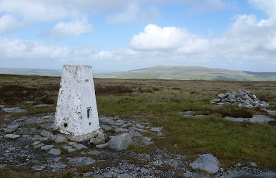
Burnhope Seat

Burnhope Seat Trig
       A short walk across the border from Cumbria into County Durham. Taking my life in my hands there, dangerously close to Pieman country! We parked below the forlorn looking ski tows of Yad Moss and followed the towline up onto the broad plateau. This was damp underfoot to say the least, many detours were made to avoid the worst bits. The trig point is in County Durham but only by 20metres or so, it is unusual as its built on a large plinth with a couple of steps so that Marilyn baggers can surmount it with ease. Although it had been dry so far the weather was closing in over in the west, so beat a hasty retreat to Darn Gill. The old mine level marked on the map was found just as the rain came pouring down. A while sheltering under the road bridge and still the rain came down, so on with the waterproofs and as we set off back to the car of course the rain stopped.

Sunday, 29 May 2011

Birk Fell

Buckden Pike behind the trig on Birk fell

        A dismal morning, high winds and driving rain, so I wasn't going to venture too far. I still had the Marilyn of Birk Fell to climb, so that was why I found myself sat in the car at Arncliffe in Littondale, as it rocked on its springs. At least the rain had stopped, so off I went. I walked up onto the ridge helped by the westerly, once on the ridge the wall provided a bit of shelter. The path hugs the wall for most of the way thank goodness, after a couple of miles the trig appears to the east of the path. This however, according to the book isn't the summit. The actual highpoint of Birk Fell is about another mile further on, it is marked by a small cairn. I retraced my steps to the bridleway, and followed it down to the hamlet of Litton. The valley was sheltered and gentle meadow paths led me back to the car. This completes the ascent of the Marilyns in the dales so its time to move on to pastures new in the search for more summits.
Summit of Birk Fell 

Sunday, 22 May 2011

Hard Level Gill

Ruins of Old Gang Smelt Mill
    On the way back home from Hoove and with the weather improving I decided to have a mosey up Hard level Gill as far as the old mines and smelt mill at Old Gang. Much of the buildings have had their imminent collapse arrested with careful remedial work. These buildings will be familiar to "Coast to Coast" walkers, the route goes right past them.

Hoove

East from the trig on Hoove
        A wild, windy day with heavy showers. I parked on the top of "The Stang", near Arkengarthdale, and headed roughly west into the teeth of the gale. Todays target was Hoove, a little trod "Marilyn." It was only about 1 mile to the grid reference which was in theory the high point of this mainly featureless moorland. Even the rock outcrop marked on the map wasn't there! The designated point looked no higher than the trig point which was a few hundred yards to the north. I visited this as well for completeness.

Thursday, 19 May 2011

Ilkley Moor

Gritstone blocks near the summit
        Ilkley Moor is a Marilyn, and other jobs in the area  gave me an opportunity to visit the top. I must admit that the vast amount of the work was done by the motorbike, a tarmaced road takes one all the way to the ridge. (Just beyond the radio masts in the photo.) The path was in the process of being repaired, there were lots of pallets of gritstone slabs waiting to be placed in crucial spots. At last we have had some better weather, the sun has shone, although tempered by a cool wind.

Sunday, 15 May 2011

Winter Hill

Memorial Stone: 100 years since reclaiming the public right of way
       Another wet day, very wet and windy in-fact! I had seen the mast on Winter hill from a distance many times, but today with Ian I visited the mast up close, and of course the trig point. We ascended Smithhills Moor and stopped at the shooting hut for a spot of lunch. Sadly we were only able to see perhaps 80ft of the total 1035ft. Our route for the return leg lay along Dean Ditch, the path was wet to say the least! It was a shame that the weather was so poor, and that I was unable to see the huge mast in all its glory. I shall have to go back, possibly on the bike up the private access road.