Wednesday 29 May 2019

Pen-y-ghent and Plover Hill

An early start (well for me) today. The forecast was for a worsening kinda day, the rain would take longer to arrive in the East so off to Horton-in-Ribblesdale I went. Parking was easy! it is half-term after all.
It seemed only recently that I'd been up Pen-y-ghent, but having checked my records when I returned home...it was last January! Time fly's when you're having fun :-)
Poor light today so the images are nothing special, just a record for me really...

Pen-y-ghent from Horton Bridge

Having walked up the lane past the school and through Brackenbottom, once on Brackenbottom Scar the view opens up and Pen-y-ghent starts to look rather closer.

Looking back down the "nose" over Gavel Rigg and beyond to Pendle Hill.

Just an hour to reach the top, and over in the distance...Plover Hill, my next target. You soon leave the crowds behind when you leave the main drag here.

After the recent dry weather I expected the path across to Plover Hill to be dryer than it was...I just managed to do it with dry feet in my Inov8's...lots of dodging about to achieve it though.

Having had a snack behind the summit wall out of the chilly wind I descended beside the wall to the Foxup Moor track, passing these boulders on the edge. Ingleborough in the distance.

Along the Foxup track and the next sight of note...Hull Pot. Lots of new stones have been brought down by Hull Pot Beck. I was told that earlier this year that it had filled Hull Pot completely! 

I had to walk about 250m upstream to find any water in the beck at all today...attractive little fall though. Within 10m or so all the water disappears through the stones and gravel in the bed of the beck.
Back to Hull Pot and down the lane to Horton and the car. The first spots of rain were just starting as I arrived at the car...the early start had paid off.


Tuesday 28 May 2019

After Work Stroll Up Farleton Knott....

A long dull day at work meant it was important that I get out and re-motivate myself...a stroll up onto Farleton Knott, my local hill would be just the ticket. I also wanted to try out something new tripod wise as well. I used both my Lumix LX3 (Compact) and Lumix GX80 (Micro Four Thirds), they're both capable of producing results far better than their owner! Enough preamble here's a few pics...

Birds Foot Trefoil, loads of this up on the Knott at the moment...LX3

Googling" lightweight tripod for backpacking" resulted in a Youtube clip of a variation on this idea. The clip showed just one peg and cord, with the trekking poles cantilevered...This is the GX80 on a 1K Gorillapod...really steady the camera and lens weighs over 500g....LX3

This is the same set up but with the LX3 on the tiny Original Gorillapod. The LX3 is just over 250g so is more than happy on this mount. The idea works well...unless you can't get pegs in!!....GX80

All you need...plus a couple of trekking poles of course for a compact camera similar in weight to a LX3....GX80

If the camera is heavier the larger Gorillapod is required. You could use much thinner cord in both cases though, I just grabbed this from my "bits bag". If backpacking just keep a couple of pegs to one side when striking camp....just don't lose them otherwise erection of your shelter might be compromised....don't blame me!....LX3

West from near to the top of Farleton Knott, Coniston Fells in the distance. It would have been good to stay up there for the sunset....but I hadn't eaten since 12 noon....GX80

Taken from the same point looking North along the summit rocks...GX80

Looking back at the crags and summit, taken in 16x9 format....LX3
Always good to be out, a real tonic after being inside all day.

Monday 27 May 2019

Whitbarrow Scar from Millside

Another local walk today, once again avoiding the Bank Holiday madness. Whitbarrow is nice and local, and by taking minor roads for the most part the journey is traffic free. I t was a better day than forecast...at least compared to the forecast I saw. I haven't been up this way for a long while, so it made a pleasant change....

Having walked up through Low Fell End farm and into the wood, I followed the zig-zag path upwards. Before entering Farrers Allotment I walked onto the clearing shown above to see the excellent view over towards Hampsfell.

The Silver Birches are doing really well up here in the Cumbria Wildlife Trust Reserve...good to see.

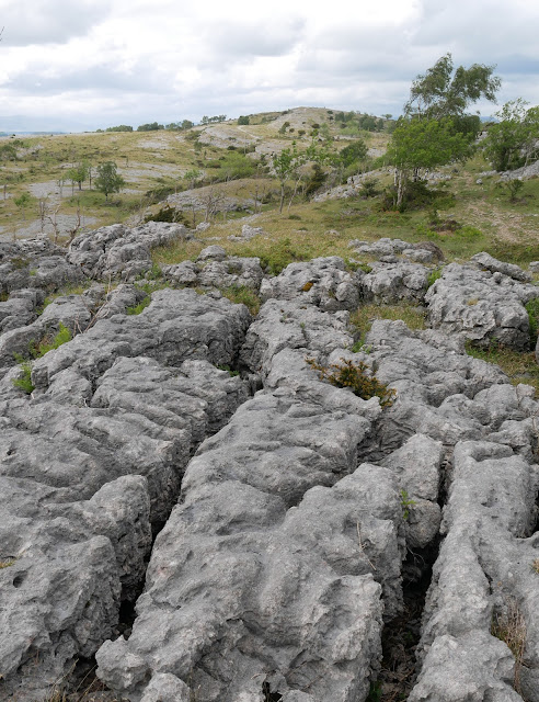
Looking across the limestone pavement towards the top...Lords Seat.

Another view of Lords Seat, framed by one of the wind blown Yews.

Mother-in-Law's Tongue.

The path I'd just walked along, the clouds starting to mass...rain not far away.

At the top, once again the weather over the Lakes looked a bit iffy...better down here near the coast.

I dropped down the steep path just North of Chapel Head Scar. Then across the field in the image above. Once on the road the rain came on, so no more photos...bridleway to Beck Head and minor road back to the car....work tomorrow :-(

Sunday 26 May 2019

A Walk to the Coast....From Home.. (Holme)!

Waking to a dull, drizzly morning it was difficult to get motivated to do anything more than drink coffee and read. The forecast was for it to improve, and by 12ish things were looking better. Rather than drive somewhere in the Bank Holiday traffic I decided to walk from home. Sandside on the Kent estuary would be the objective.....

First lane of the day at Elmsfield, Farleton Knott in the background.

Across the River Bela at Hang Bridge

Having walked along Hangbridge Lane I crossed the Bela again here at Heron Corn Mill.

Through Dallam Park, with it's resident herd of Fallow Deer.

They're not tame...but not wild either!

Dallam Tower, home of the Wilson's

Having crossed the B5282, I was almost at the seaside. A look back at Milnthorpe Bridge.

A Goosander and its family...Mum operating a taxi service!


As I climbed over Haverbrack a look back North to the Lakes, and it looked wet.

Then across Beetham Fell to "Fairy Steps"...seems to me its getting narrower :-)

Much of my route bakc from the Fairy Steps forms part of the Limestone Link.

Farleton Knott taken from the footbridge over the West Coast mainline...almost home.
Something a little different, I'm usually on the pushbike round these lanes rather than my feet.
Anyone interested in my route would be best looking at my Strava track here .

Friday 24 May 2019

The Duddon Valley and Wrynose....on the Motorbike

After 5 days of walking...of various difficulty and effort I felt it was time for a day on the motorbike. I seem to have mainly used it or commuting this year, so a micro tour was in order. I set off across the A590 to the West, I stopped off to check how the Ospreys were doing at a non-publicised nest. Both birds were in attendance, I only had compact binoculars so couldn't see much else. Then I rode up the Western side of Coniston Water....some photos of the day.

Dow crag and Coniston Old Man, the backdrop to Torver.
Back on the bike I crossed over to the Duddon Valley via Broughton Mills and Seathwaite.

I had hoped to take some pictures of Tarn Beck near Seathwaite...but there was barely any water!
The photo above is at Birks Bridge looking downstream.

Strangely worn rock under the bridge.
This pool features in Ken Russells film "Tommy" The Who's rock opera.

The Duddon above the bridge and the lower slopes of Harter Fell

Dale Head shining white against a shadowy Little Stand

Once over Wrynose it was much brighter...and warmer! I stopped to look across at the Langdale Pikes. From here it was back home via Little Langdale, Waterhead, Bowness and the Lyth Valley (always much quieter than the A591 and nicer on the motorbike.
A great day, good to be back on the motorbike purely for pleasure.

Wednesday 22 May 2019

Hart Fell...In the Moffat Hills

So, having burnt some more fossil fuel, I found myself high in Annandale near Ericstane. Today's initial target was the Corbett of Hart Fell. From there I would see how I felt and how the weather fared. Parking near the community hall off I went....

The hamlet of Ericstane and the head of Annandale

The Auchencat Burn which I would follow for the first part of my route.

The scree filled gully contains "Hartfell Spa"...next on the agenda.

This is the "Hartfell Spa" a chalybeate well, apparently good for curing ills...although the water looked like it would give you ills rather than cure any!

Things got a bit scrambley near the top of the gully

And here looking back down the gully towards Annandale. The prominent hill is I think Queensberry.

Lots of Mayflower about today.

Click on the image to increase the size otherwise you won't see all the wind turbines!
I have mixed feelings about them...there's an awful lot of them here though.

This is the subsidiary top of Arthur's Seat, to the left of the cairn in the distance is Skiddaw and over to the right of the image Criffel.

Yours trulyon the summit of Hart Fell gazing towards White Coomb.

It was a brutal descent beside the fence, out of view before climbing back onto the broad ridge in the middle of the photo...Whitehope Heights..a Donald.

Continuing beside the fence along the broad twisting ridge I joined the Annandale Way...marked by this cairn.

I stpped at the next col for a snack and drink, a great view down Annandale

Over my last top of the day Great Hill, I then picked up this great path which contoured under Strait Step. 

There were excellent views of the Devils Beef Tub from the path.
The path took me down to the valley floor at Corehead, from there it was road/Land rover track back to the car via Ericstane.
Superb weather, and a great horseshoe walk. Only one person seen (on Hart Fell summit) all day, quiet hills for sure.