Wednesday, 1 November 2017

Revisiting Some Tops Above Langdale

Not quite the early start I'd planned as I left the car in Chapel Stile at 10.20am. I had a vague plan to visit as many summits (they had to be listed on here ) as I could energy permitting! In the available time...I wanted to be back at the car for about 4.30pm. So off I went up through Walthwaite to climb steeply beside Megs Gill. There's rather a lot of pictures......

Once the "ridge" was reached the great view over Grasmere and Rydal Water was revealed

Shortly after I was on the summit of Silver Howe, my first top of the day.

Next on the agenda Lang How. This is the view from the top looking up Langdale

This is the rounded top of Swinescar Pike, sunbeams lighting up the valley beyond

Next Little Castle How, more sunbeams :-)

Lots of up and down, twisting and turning over castle How (Raw Pike) and Great Castle How brought me to Blea Rigg seen here looking back East along the ridge

Further on the ridge you see Blea Tarn and its surrounding fells 

Its a bit of a pull up to Sergeant Man, although there was welcome shelter from the stiff breeze.

After a spot of lunch I set off across the very wet path to High Raise ( I realised I'd missed the top of Codale Head part way across but chose not to go back for it :-( ). There was a good view down towards Borrowdale, I didn't linger due to the cold wind. Instead turning South and passing over Thurnacar Knott.

Its only a short distance to Pavey Ark, here on the summit is the aerial view down to Blea Tarn.

I always think its rough ground between Pavey Ark and Harrison Stickle, maybe its just me?
Great view of Pavey Ark mind!

A proper drop and climb brings you to Pike O'Stickle, wild on top today. The last couple of tops of today's walk are long the ridge in the centre of the image.

Loft Crag with Harrison Stickle behind....and Thorn Crag below.

Its a steep descent down to the valley floor. I stopped here to eat what was left of my lunch and totted up the tops. 9 Wainwrights, 4 Birketts and 2 Synge's, quite happy with that.
Of course I still had to walk back to the car in Chapel Stile, it's an easy walk along the valley bottom tho.
There's a Strava track here if anyone wants to see my route.

Sunday, 29 October 2017

Last of the Autumn Colours in the Lowther Valley

A really beautiful day, we've barely seen the sun up here for ages!....It's grim Up North!!
This is another walk we've done many times, it's one of P's favourites. Not very far, and mainly on the level which is kind to poorly knee joints. We parked in Askham  and wandered up the valley.

Beside the River Lowther near Crookwath bridge

Further on looking upstream from the footbridge below Whale

Back through Lowther Park with the trees showing the last of their Autumn colours

Almost back at the car, we lingered in the warm afternoon sun at Askham Bridge. Just a short walk up through the village stopping for coffee on the way.
Lets hope there are lots more sunny days in the near future :-)

Wednesday, 18 October 2017

Out With Old Mate Tim For a Days Mountainbiking

Tim and I have been trying to get out for a day on the Mountain Bikes for almost 6 months. Today was the day! We parked near Force Mills, the weather almost perfect. We headed South on varius bridleways towards Rusland, visiting the ford at Rusland Pool. I didn't take many pics...we were to busy chatting about adventures we'd had 40 years ago on these same trails! Here's one or to anyway...

This is a vehicle trap!!  "Get me out says Fatty!"
The idea being that no vehicles should use the ford at this time of year to help the fish.
We had no intention of crossing anyway, and turned and continued our route.
We climbed up to High Ickenthwaite and over to Nibthwaite. The Parkamoor Road was next...

Here as we climbed up the old track the views over to the Coniston Fells was excellent.

After lunch just South of Parkamoor, we continued on the bridleway high above Coniston Water.
This is one of the best viewpoints I know of the Coniston Fells (its above Heald Brow)
From here we dropped down to Bank Ground, before climbing back over Grizedale Moor.
A bit of "North Face Trail" led us back to Grizedale, then more bridleways back to the car.  

Back at the car and bike washed...Fatty was tired I think, had to sit down!
We'd had a great day, in great weather!
Thanks Tim! :-))
Should anyone want to follow our route, the Strava track is here 

Thursday, 5 October 2017

A Bit of a Hike...Followed By a Bit of Bike

Finding myself free for the day at short notice and with the weather looking superb, I decided on a walk first then a ride on the bike later. Having parked on the top of Kirkstone I headed east.....

Once on St. Ravens Edge the way forward is laid out before you, together with a grand view down towards Patterdale.

As the path dips to the head of Woundale there were a number of bags of rocks...looks like the path is going to be repaired.

I had lunch here sheltering behind the wall from the stiff breeze.
The Southern reaches of Windermere is visible in the distance.

The summit of Caudale Moor. The Helvellyn range seen to the left of the cairn.

I then crossed over some very wet ground (its done nowt but rain for ages!)to Stoney Cove Pike.
As a lad I knew all this area as "John Bells Banner"....it was what my Grandad called it!!
I reversed the route back to the car.
After the short drive home I had a coffee and slab of Soreen (other maltloafs are available!) got changed and went out on the bike towards Warton Crag. 

Beside the view indicator on Arnside Knott looking Northwest.
There was as ever recently a hell of a wind!
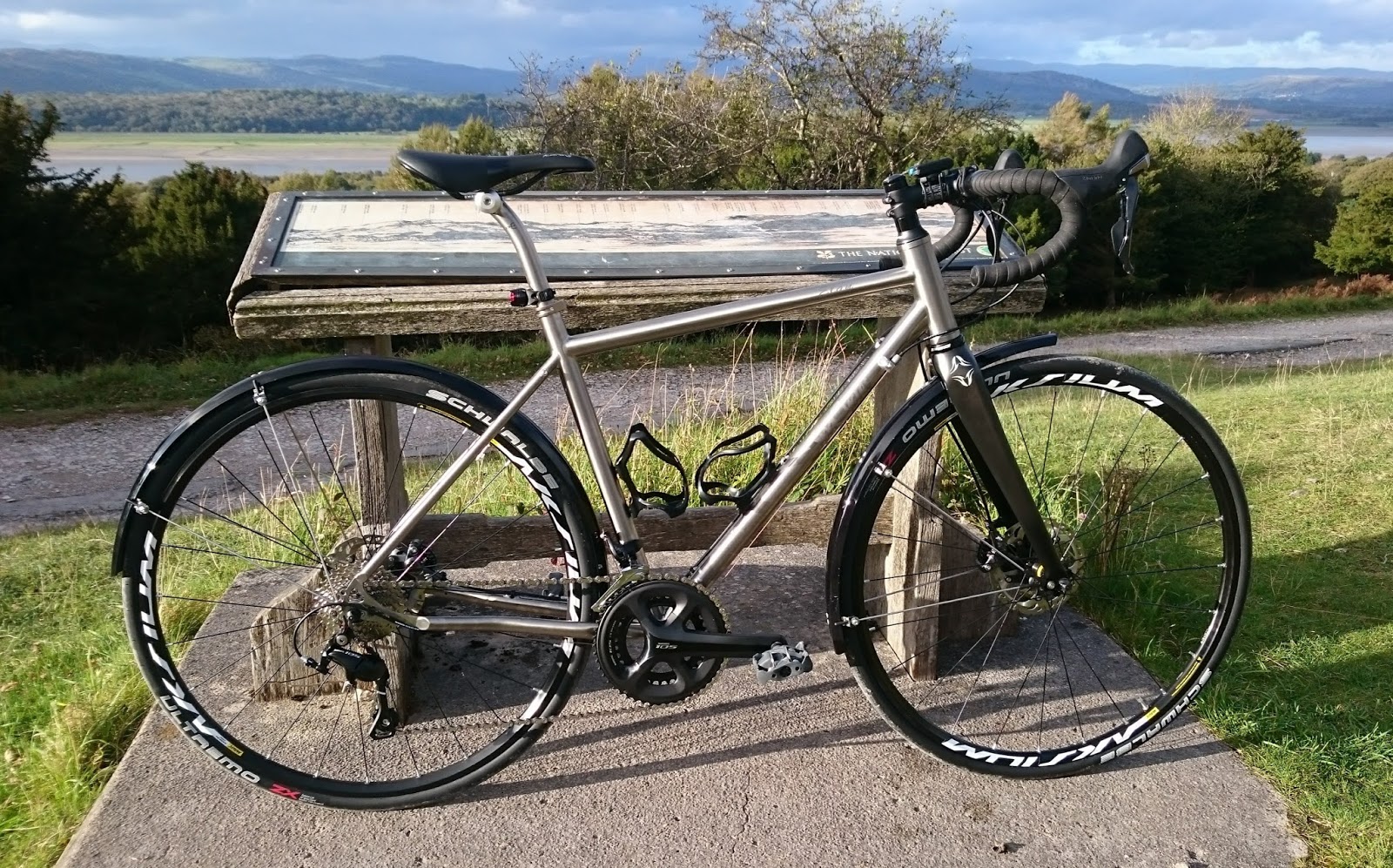
This is my 60th Birthday present to myself, (albeit a bit after the fact) a Spa Elan. Not purchased to replace any of my other machines but for a specific purpose.....which I think it will suit admirably. There will be more posts on this in the future I'm sure This was my first proper ride on it and I must say so far I'm very pleased :-)

From high on the Knott it was back to sea level, after a pause on the Stone pier I headed back home well satisfied with my use of the day.


Thursday, 14 September 2017

A Wander from Langcliffe

Another walk today which I've done numerous times. I always enjoy it so why not do it again! The weather behaved itself in the main, just one heavy shower that lasted 5mins...a tree provided handy shelter. Here's a few pictures from the day........

No walk hereabouts can miss out on the Hoffman Kiln

Across the fields to Stainforth, then the Pennine Bridleway up to...

...Catrigg Foss.
(This and the next photo were handheld at a very slow shutter speed so sorry for the blurring)

A closer view of the force

Pen-y-Gent sen beyond the narrow valley of Catrigg Foss

Winskill Stones with Inglebrough in the distance.
From here Victoria Cave and Warrendale Knotts and back to the car on more Pennine Bridleway, although I didn't take any pics?!

Thursday, 31 August 2017

Mooching Round the Mines at Nenthead

Over to Nenthead in the North Pennines, and the heart of the lead mineral mining area today. I was with old mate Bill, although I visit Nenthead on a fairly regular basis lots of todays walk was new to both of us. We were blessed with the weather, here's a few pictures of the day.....

Carrs Level (I think!) As I understand it, this is the entrance used for the mine tours...Approx 10 days a year....I need to get on one of these sometime!

Looking back down towards Nenthead from the entrance to Carrs level

The entrance to Smallcleugh Mine and to its right the remains of the Smithy/mine shop.

Bill further up Old Carrs Burn

Mine Tub in Middlecleugh Mine

The smaller of the 2 reservoirs built to supply water to the mines

Another Level, Brownley Hill Mine

The public fountain in the centre of the village.
Hadn't they ever though about carrying a sports bottle of expensive water everywhere with them! 

Thursday, 24 August 2017

An Upland Wander Above Patterdale

This was a walk which didn't trouble any summits! I was more intent on dodging the heavy showers as they were blown in on the stiff SW wind. This is always an enjoyable walk, one I have done many times....it fills in an interesting half day. Here's some pics of the day....


Looking back at Place Fell...the "Fix the Fells" path is at last starting to blend in!
Glenridding and the head of Ullswater seen across Chapel-in-the-Hause

Angletarn with Satura Crag and Rest Dodd behind.
Centre left in the picture you can see a tent....just being taken down at 11.45am! 

Another view over Angletarn...sparkling after one of the showers had passed through.

Looking down Bannerdale from Satura Crag

Back down by Hayeswater Gill.
The recent work on the Hydro scheme is blending in well here :-)