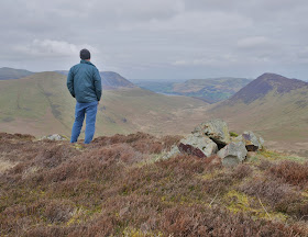
Sunday 31 March 2019

My Last Synge* and A Circuit of Ennerdale Water

* Except for Pillar Rock....What a pain!
Early start for me this morning, I arrived at Bleach Green car park before 9am to be greeted by a cold breeze and a low sun. I had just the one Synge left (other than Pillar Rock) Boat How, nestled under Boat How Crag to the South of Ennerdale Water. I'd mulled over several methods of ascent, but decided to go via Anglers Crag.

I soon reached Anglers Crag, here looking across the saddle to Crag Fell. 

And here looking up Ennerdale

From Anglers Crag I contoured across some horrendous pathless terrain to reach this point.I had made a bad route choice, seduced by the promise of a path I'd seen on Google Earth!
My quarry is Boat How, the shadowy hump to the left of the trees in the image.

Another selfie...this is becoming a habit!
I felt justified as this was my last Synge 647 of the blighters...Yea I Know, except Pillar Rock. Anglers Crag is below me in the middle distance. All those miles thrashing through heather, bog and bracken to reach a point on the map that most folk have never even heard of! I've enjoyed it though, I'm always happier visiting somewhere new....even if it might not be as good (and that's subjective of course)as the more popular hills/destinations.  

I made a direct descent to the shore of Ennerdale Water.
And found....a lone tree! Who knew it!! It's a better one than the Buttermere Tree IMHO...more difficult to access though.
Starling Dodd is the hill framed between its branches.

As I approached the head of the lake the wind had dropped, there were flies everywhere taking advantage of the warm morning no doubt.
This view is looking Northwest to Herdus Scaw or Great Borne

As I headed back towards the North shore, the sun had disappeared and the sky was overcast. I dropped down beside the River Liza to take a photo looking back at Pillar.

Lots of Primroses in the woods now.

Its a lovely flat walk from just below Bowness back to the car park, it would be absolutely packed if it were at a central Lakes honeypot. It gives great views across the lake to Crag Fell.

This photo was taken of Herdus (Great Borne) and Bowness Knott close to the site of the old "Fish Inn" long since demolished. It would have been a bit of a money spinner today!
Just a short stroll from here to the car park, another great day.
Time to turn my sights to other objectives...What I could really do with is a benefactor with afilling station! :-))

Wednesday 27 March 2019

A Single Synge Bagged....and A Circuit of Crummock Water

Back to Buttermere this morning...the car will know it's own way before long! I had a definite plan for the day, unusual for me at the moment. First on the agenda was a visit to Scale Force, it's probably 14 years since I'd been there. Then the Synge of Gale Fell East Top, and finally a stroll round Crummack Water. As is my habit, there follows a few photos of the day......

Scale Force...I did scramble up and above the lower fall, but the image was in my opinion poorer.

The summit of Gale Fell East Top....and a rare appearance by your author!
This is the view North...ish Loweswater just visible. 

I descended to the shore of Crummock Water and had my lunch here with the view across the lake from Low Ling Crag towards Hause Point.

Whiteless Pike and Rannerdale Knotts, again from Low Ling Crag

Further along the shore looking towards Whiteside.

Rannerdale Knotts seen between these Silver Birches

A telephoto image compressing the view up Gasgale Gill...amazingly when zoomed in it's possible to see someone on top of Hopegill Head. 

Grasmoor, and its reflection doing its "pyramid" impression.

Still a few Catkins about!

Horse Chestnuts are bursting open with the promise of a bit of sunshine

Whiteless Pike as I walked on the short section of road.

The highpoint in this image is Gale Fell East Top, I took the photo as I dropped off the bridleway on Rannerdale Knotts. From here I walked on the permissive paths, round Nether How and beside Mill Beck back to Buttermere and the car.
A full day, most enjoyable as well....great to see a bit of sun :-) 

Thursday 21 March 2019

Buttermere...A Few Hours With the Camera

After yesterdays "exertions" climbing the 2 lower hills I had thought of adding Gale Fell East Top, West of Scale Force to the day. However arriving at Buttermere the cloud was way below its summit, and basically I just wasn't "feeling it"! So decided to take a few images...a bit of practice with the camera. Here's the results...nothing original I'm afraid and the light was poor really.

Trees at the Southern end of Crummock Water

The lone tree Buttermere

Southwest down Buttermere to Fleetwith Pike

The bottom fall of Sour Milk Gill

Across Buttermere to High Snockrigg...who the hell put that wire there? It's serving no purpose whatsoever...there's a huge gap in the fence just out of shot!

Wednesday 20 March 2019

No Boring Hills...Only Boring People?

I remember reading this many years ago, I think in one of Hamish Brown's books. Many folk either wouldn't "waste" their time, or say that the 2 hills I climbed today were indeed boring. But I beg to differ, they both took me to areas that I seldom visit these days. If I wasn't ticking off Synge's I doubt I would ever have climbed either of them. they were both out and back walks. A couple of pictures from the day.....

The summit of Latrigg (not the Keswick one!) it s a little East of Binsey. Surprisingly it has a cairn..there is no public path to, or anywhere near the summit and sadly it's not access land. So as is the tradition on this blog there is no mention of my route.

I then drove West...ish to climb Embleton High Common. I parked near High Harrot Farm and walked up the good track which helpfully takes you up to the access land near these 2 Scots pines.

It was only a few hundred metres across the fell to the summit of Embleton High Common 319m. As you can see from the image the cloud was down, no cairn here my poles are stuck in the highpoint...even though it doesn't look it!
The weather improved once back at the car, so I drove round to Buttermere. I'll make that a separate post.

Thursday 14 March 2019

Finishing the Central Fells Synges

I didn't expect to be back so soon...I was only free at the last minute, so headed back to Borrowdale and parked below Grange Crags. Then weather was like a carbon copy of yesterday, although there was apromise of a better afternoon. I walked along the road to High Lodore then took the path which zig-zags up behind the farm. My first Synge was Brown Dodd, it was the usual thrash through bog, dead bracken and heather...here's a few photos to give a taste of the day.

As I gained height the views were opening up, and all around me were lots of Silver Birches

The Lakes has had a fair bit of rain recently, Derwentwater a good deal larger than normal!

The top of Brown Dodd, looking North across Derwentwater to the Skiddaw group wearing a cloak of cloud.

I thought the high point in this image was my next top...but it was a good bit beyond.
Isn't it always the way?

The top of Ether Knott...it's got a cairn! albeit a small one. It even had a sketchy path to the top from the South. Maybe because it's a good viewpoint for Watendlath and it's Tarn.

I descended to Watendlath in lashing rain, had a bite to eat under the best shelter I could find. I then headed down the valley, years since I'd been on this path...seems to have been improved from what I remember.

Down beside the roaring upper Lodore Falls

I'd made good time so stopped for a brew in a spell of sunshine amongst the Birches on Sheperds Crag

A good chance to take a telephoto shot of the footbridge over the River Derwent...boat or canoe needed for access today!
From Shepherds Crag I descended to the road and walked back along it to the car, getting caught in the heaviest shower of the day!
A great day though, I felt good after yesterdays headaches etc and another area of Synges completed only 5 left to go (inc Pillar Rock!)

Castlerigg Stone Circle
Nothing to do with today's wander but as I was leaving Keswick the weather had brightened up.
I guessed there wouldn't be many folk about (there wasn't) so I took a couple of photos

Another photo of the stone circle with Blencathra in the Background

Today's schoolboy error....not wearing my specs when picking my map out this morning!!
I actually hadn't realised until I got my food out at Watendlath, I'd kind of committed my route to memory before I left home....if the visibility had been poor of course.....

Wednesday 13 March 2019

Back to Synge Bagging

After a brief hiatus, it was back to Synge Bagging today. It had been a very wild night, and it was still windy this morning as I parked up in Stonethwaite. My intention was to try and climb my last 3 Synges in the Central Fells...but then best laid plans....


I climbed the steep path beside Willygrass Gill. Most people would stay on this path to either visit Dock Tarn or Great Crag...or maybe cross over to Watendlath. Of course I had other plans, no lovely path for me...off I strode through thigh deep heather to climb "Knotts" Eventually arriving at this point...not the top sadly.
 
But this is the top of Knotts. looking back across more deep heather to the point I was at a few minutes before. I descended to an old sheepfold and had some lunch. Might have been the wind (although I had a hat on and my hood up) but I was suffering with a real bad headache :-(
I felt I should descend to the valley rather that press on for the other tops...they'll be there another day I'm sure.

It was steep rough ground, this spooky old tree about the only thing of note, although the sun was trying to make an appearance...it was still incredibly windy though.

Once back in the Stonethwaite valley it was easy walking on the bridleway then the road back to the car. I drove into Keswick and had a mooch about, then drove home.
It's not like me to be "ailing", and as I write this I feel considerably better.

Wednesday 6 March 2019

Scout Scar.....and Leighton Moss!

An unexpected free morning.....where to go...Scout Scar! It's ages since I'd been up here even though I work within 3km of the summit! Nothing much has changed though, except perhaps the paths look more heavily used. I parked on the Brigsteer Road and headed North...

I hugged the scar edge, it was looking grim up in the Lakes

As I approached the highest part of the cliff these Scots Pines caught my eye...

Looking back towards a hazy Arnside Knott things looked a lot brighter.

I turned to head back at the viewpoint, known as the "Mushroom" by local folk.

Leaving the "Mushroom" behind I walked along the top of the scar calling at the trig point, before crossing Helsington Barrows back to the car.
I thought I'd take advantage of the better than forecast weather.....

.....and made a detour to Leighton Moss RSPB reserve. The only slightly unusual birds being this pair of Grebes.

The weather was deteriorating...thunder and lightning approaching. I quickly took this photo before the heavens opened. Just a couple of miles to home from here, it had been an easy day. Enjoyable though.